
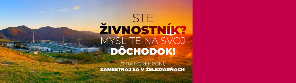
Pre živnostníkov - pracovné ponuky
Pracujte v ŽP a.s. a NIE na živnosť, práca v stabilnej hutníckej spoločnosti, vyšší dôchodok, príspevok zamestnávateľa na DDS až do výšky 4%, cena jedla pre zamestnanca vo výške 1,01 EUR ...
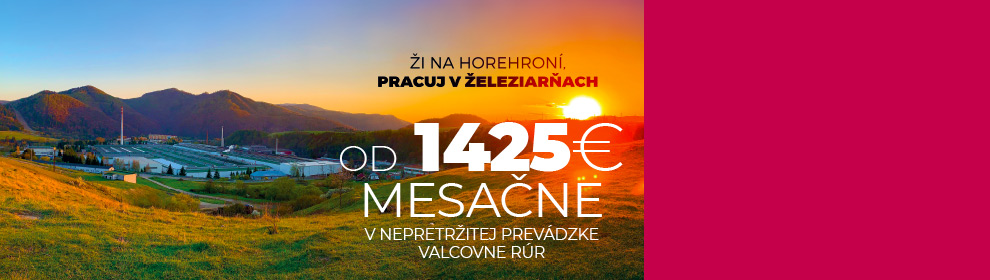
Zamestnanec hutníckej výroby valcovňa rúr
Železiarne Podbrezová a.s., plný úväzok, nástup ihneď, mzdové podmienky (brutto) 1 425 - 1 500 EUR/mesiac (8,73 EUR/hod. – 9,20 EUR/hod.), pri trojzmennom pracovnom režime
Portál oceľové rúry
Portál pre všetkých spotrebiteľov oceľových rúr ponúka komplexné informácie o výrobnom programe spoločnosti Železiarne Podbrezová a. s., certifikáty a osvedčenia ako aj množstvo užívateľských nástrojov


čo sme
Šport
| Súčasťou filozofie akciových spoločností ŠK a FK Železiarne Podbrezová, a.s. je myšlienka vytvárania športových klubov mládeže od útleho veku. Cieľom je jednak podporovať talentovaných športovcov, ktorí budú môcť svoje schopnosti rozvíjať aj štúdiom v Súkromnom športovom gymnáziu ŽP, ale súčasne pravidelne organizovaná športová činnosť odpútava deti od negatívnych vplyvov, ktoré v civilizovanom svete číhajú na každom kroku. |
Akciové spoločností ŠK a FK Železiarne Podbrezová, a.s. (v minulosti ŽP Šport, a. s.) vznikli 1. 1. 1999 a hneď sa zaradili medzi významných propagátorov športu a zdravého životného štýlu na Horehroní. Ambíciou ich generálneho partnera Železiarní Podbrezová a. s. a ich dcérskych spoločností bolo, aby sa tieto športové organizácie svojou činnosťou podieľali na rozsiahlom sociálnom programe. Ten vedenie fabriky realizuje pre svojich zamestnancov už niekoľko rokov.
Jednou z priorít týchto spoločností je práca s mládežou a spopularizovanie športu pre všetky vrstvy. Na to je skvelým podporným prostriedkom veľké množstvo športových podujatí, ktoré spoločností organizujú. Medzi ne patrí napríklad Turnaj základných škôl o pohár Generálneho riaditeľa Železiarní Podbrezová vo futbale. Niektoré akcie už dávno preklenuli lokálny rámec a organizujú sa na medzinárodnej úrovni. Je to Svetový pohár v kolkoch, Liga majstrov v kolkoch či Slovenský pohár v cyklokrose.
Prácu s mládežou na vyššej, profesionálnej úrovni umožňujú týmto spoločnostiam školské športové strediská, ktoré spoločnosť ŽP Šport v minulosti založila, a to futbalové triedy na Základnej škole Pionierska 4 v Brezne. Súkromné stredné odborné učilište hutnícke Železiarní Podbrezová, ktorého súčasťou je aj Športové gymnázium, zastrešujú nasledovné športové odvetvia: futbal, atletika, biatlon, golf, snowboard.
Spoločnosť ŽP Šport, a.s. a jej nasledovnícke spoločnosti FK a ŠK Železiarne Podbrezová, a.s. spočiatku technicky, personálne, logisticky i odborne zastrešovali širokú plejádu športových odvetví. Postupne sa ich činnosť vyprofilovala a v súčasnosti koordinujú činnosť týchto športových oddielov: futbal, kolky, cyklistika, lyžovanie, balónové lietanie a biatlon. Ich zabezpečenie, podpora, práca a rozsah činnosti predstavuje rôzne úrovne.
Úplným vrcholom pyramídy je profesionálne zabezpečenie športovcov a ich realizačných tímov. Pre potreby obyvateľov blízkeho regiónu Horehronia sú aktivity spojené s prevádzkovaním športových zariadení.
Spoločnosť ŠK Železiarne Podbrezová, a.s v rámci svojich podnikateľských aktivít ponúka verejnosti ubytovacie, pohostinské a dopravné služby, letné kúpalisko s vyhrievanou vodou a mnoho iného.
Pre rozšírenie hráčskeho a diváckeho komfortu prebehla v roku 2015 rekonštrukcia futbalového štadióna, ktorý dostal názov ZELPO Aréna. Táto významná investícia do športovej infraštruktúry bola spolufinancovaná zo štátneho rozpočtu v oblasti športu.
Viac informácií o športe:
www.skzp.sk
www.zpfutbal.sk
/36162D727D202E14C1257C22003B8856/$file/2013_turnaj_2013GR47.jpg)
/31645368756578CBC1257C2200457FFB/$file/Semifinale_zeny_CHL2013-10.jpg)
/082F312F9F7AE5C2C1257C22004516DF/$file/ZP_futbal_A.jpg)